In various radar training and signal simulators, track simulation and track display are required to provide a signal source for the simulation platform. For portable radar simulators, PCs cannot be used, and embedded systems are required for human-computer interaction and signal processing. However, most of the current track simulations are built on PCs. Although powerful, the track models are complex and computationally intensive, and are not easy to implement on embedded devices. In view of the above problems, in the embedded system, the double buffering technology is adopted, and the three typical radar track models are simulated by the "background copying" method, which solves the memory processing speed and drawing of the embedded system during simulation. The contradiction of large resource consumption realizes the real-time dynamic simulation of the graphical display of typical radar tracks and the coordinates of the track points.
1 typical track modelThe so-called track is the radar measurement time series of the flying object, which is an important parameter reflecting the target flight path, speed, and even the purpose of the flight. Linear track, horizontal circular track and vertical circular track are three typical air track models. The combination of three typical tracks can effectively simulate various complex tracks in the air.
1.1 Establishment of the coordinate system
The common coordinate system of the radar system has a Cartesian coordinate system and a polar coordinate system. Both use the radar as the origin of the coordinate system and the origins coincide. In the Cartesian coordinate system, the positive direction of the y-axis is positive north, the positive east is the positive direction of the x-axis, and the horizontal and vertical directions are the positive direction of the h-axis; in the polar coordinate system, the line is connected from the observation point to the target point. The direction of the extension line is the positive direction of the target oblique distance D.
1.2 Establishment of the track model
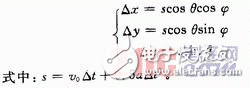
1. 2.1 Straight track
The spatial straight track is relatively simple and is the most commonly used track model. The kinematics equation in the Cartesian coordinate system can be represented by its initial velocity v0, acceleration a, flight pitch angle θ, heading angle φ and track time t. The following relationship holds true in Δt:
1.2.2 Horizontal circumferential track
The horizontal circular track is mainly divided into two types: left turn and right turn. In the Cartesian coordinate system, the equation of motion in the unit time increment Δt is as follows:
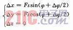
Where: s=2Rsin(△φ/2), used to represent the linear distance from the starting point of the circular motion to the ending point; R is the radius; φ is the initial heading angle, △φ=(vΔt)/R is the heading angle Increment (azimuth variation). When the target turns left, F=1, when turning right, F=-1.
1.2.3 Vertical circumferential track
The vertical circumferential track refers to the circular motion of the target in the plane perpendicular to the horizontal plane, which is characterized by the flight azimuth remaining unchanged. Assuming that the linear distance from the starting point of the target motion to the ending point is s in the unit time increment Δt, the projection of s on the x-axis is Δz, and the projection on the xoy plane is ΔL, and the following relationship can be obtained:
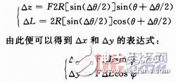
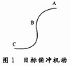
Where: R is the radius; θ is the initial flight pitch angle; φ is the initial heading angle. The pitch angle increment Δθ=(vΔt)/R. As shown in Fig. 1, if the target moves from point A to point C, F=1 when the target moves from point A to point B, and F=-1 when the target moves in section BC.
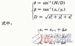
1.3 Radar coordinates of the target flight
In the radar application, the target coordinate common polar (ball) coordinate system is determined, and the position of any target in the space can be represented by the slant distance D, the azimuth angle β, and the high and low angle θ. For the sake of simplification in Section 1.2, the coordinate increments in the unit time increment Δt are calculated, but in actual calculations, the real-time coordinate values ​​should be used. Assuming that the position of the target in the Cartesian coordinate system is (xt, yt, zt), then:
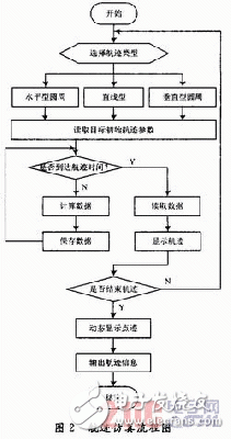
The flight path simulation process is shown in Figure 2.
An embedded system is a system that runs an application using a specific development board and a specific operating system, depending on the specific application and requirements. In general, embedded systems have the characteristics of small software code, high automation, and fast response. Compared with general PC systems, they are especially suitable for real-time and multi-tasking systems.
In the visual simulation of the track, the Win CE embedded operating system is selected, and the Visual C# language is used for programming on the Visual Studio 2005 development platform. 3.1 GDI+ technology
GDI+ technology refers to. The two-dimensional graphics, image processing and other functions provided in the .NET Framework 2.0 are mainly used to draw various image images, and can be used to draw various data graphics, mathematical simulations, and the like. Currently, GDI+ technology is the basic way to programmatically render graphics in a Windows Forms application.
GDI+ uses the Graphies class to describe a drawing surface and provides all the drawing work that the surface can do. When the desired image contains a large number of basic graphics, drawing on the Bitm-ap in memory is much faster than drawing directly on the screen. Therefore, when applying GDI+ technology drawing, in order to eliminate the screen jitter caused by drawing, double buffering technology is often used. The essence is to open a space in the memory as a buffer, draw a picture, and then draw the picture in the buffer to the user interface or output terminal. The specific steps are:
(1) Create a bitmap of the specified size of the bitmap;
(2) call the FromImage static method of the Graphics class, create a Graphics object from the bitmap;
(3) drawing with the created Graphics object;
(4) release the drawing resources;
(5) Call the form's Paint event to refresh the form.
3.2 Positioning of track coordinates
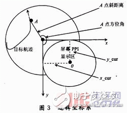
The mapping function in GDI+ is built in a logical coordinate system in pixels. The origin of the logical coordinate system is the upper left corner of the display screen, and the y axial direction is the positive direction, and the x axial right direction is the positive direction, as shown in FIG. The visual simulation of the track is based on the simulation of the radar PPI display. Therefore, in the drawing, the parameters displayed by the PPI need to be converted to values ​​in pixels.
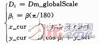
Here, we need to define a global scale m_Globalscale whose meaning is the actual distance corresponding to the screen distance, in pixels/m. Assuming that the resolution of the PPI display interface to be simulated by the system is 240 & TImes; 240 (pixels), and the maximum range of the radar is m_Range(m), the following relationship holds:
![]()
The offset between the center of the circle and the center point of the PPI display area of ​​the screen is defined as x_set and y_set. Take the point A on the track as an example. Assume that at time t, the target reaches point A. Its oblique distance is D, the unit is m; the azimuth angle is β, and the unit is (°). Point A corresponds to the oblique distance on the screen as D1, unit pixel; azimuth angle β1, unit radians; coordinates are x_cur, y_cur, unit pixels. According to the above analysis, it can be concluded that:
3.3 Dynamic display of track coordinates
The track display can be connected to all the track points by calling the drawlines() method on the drawing surface of the analog PPI display. However, in order to understand the air movement situation of the simulation target in real time, it is often necessary to simultaneously realize the dynamic display of the track coordinate points. Redrawing is a method that is often used. The idea is to redraw the static display part of the PPI display simulation interface, overwrite the already drawn track coordinate points, and then draw a new one on the new interface background. Track coordinate point.
However, considering the insufficiency of the embedded system in terms of memory and processing speed, each time redrawing a large amount of resources, it will inevitably cause waste of CPU resources and affect the timeliness of the entire system. In order to overcome the above problems and ensure the real-time performance of the entire system, this paper adopts the "background copying" method to solve. In general, the idea is to create two drawing faces, draw the track on one drawing surface (g1), then "stick" to the other drawing surface (g2), and draw the updated point coordinates on g2. When entering the next loop, the new trajectory map is again attached to g2, and then new point coordinates are drawn in g2, so that only the moving trajectory and the icon moving with the trajectory are always displayed on the form. Richly realize the dynamic display of the trajectory.
The specific steps are:
(1) Define two bitmaps Bitmap1 and Bitmap2 and set their size
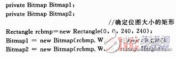
(2) Define two Graphics drawing surfaces (hereinafter referred to as g1, g2), and fill Bitmapl into g1 to facilitate the next drawing operation.
![]()
(3) Perform the track model calculation, calculate the coordinate value (x, y) of each track coordinate point, and store all the track coordinate points in the List (List is a generic type, and Point represents a two-dimensional plane) Define the ordered coordinate pairs of points). Use g1. The DrawLines() method connects all the coordinate points in the array List and displays them in the pictureBox1 control. The simulation of the typical target track of the radar can be realized.
(4) Save the entire Bitmapl that has been drawn with the track.
(5) Using the timer control in C#, taking ts as the time interval, looping out the coordinates of the track point from the List, and calling the DrawImage() function to fill the bitm-apl that has been drawn with the track into the g2 drawing surface. which is:
![]()
Then call the DrawEllipse() function on the g2 drawing surface to draw the real-time track point coordinates of the simulated target by drawing points. The dynamic display of the track coordinate points can be realized by repeating the operation of step (5).
4 is a screenshot of a radar simulator display terminal implemented in an embedded system using the method described herein, and the track depicted in FIG. 4 is a straight track.
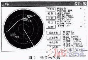
Establishing a typical radar track model and successfully implementing the simulation on the simulation platform is the prerequisite for implementing complex track simulation. In this paper, the simulation of the typical radar track is used to verify the software operating environment, optimize the program structure, and solve some problems faced by the track on the graphical display. At present, the method has been applied to the display and control terminal of a radar simulator. After field debugging, the performance is good and the real-time performance is strong, which can meet the training requirements of the radar simulator.
60V20Ah Lithium Ion Battery,Waterproof Battery Pack For Bicycle,60V 20Ah L-Ion Waterproof Battery,Rechargeable 60V Lifepo4 Lithium Battery
Jiangsu Zhitai New Energy Technology Co.,Ltd , https://www.zhitainewenergy.com